Environmental Impact

We’re in the business of helping Earth, not hurting it. To ensure our projects are environmentally conscious, we follow the permitting process and obtain all required approvals before starting construction.

Hawaii Turtles

To Minimize Land Disturbance, Nexamp…

Bullet
Sites the project in an area suitable for construction with regard to land use, zoning, and environmental setting 
Bullet
Performs site visits to confirm conditions are suitable 
Bullet
Conducts early consultation with permitting authorities and other potential agencies 
Bullet
Develops mitigation plans to address any concerns
Bullet
Collects and reviews information from available reports, studies, and documents 
Bullet
Takes into consideration surrounding property settings and impacts
Bullet
Utilizes existing ground topography and infrastructure
Bullet
Completes necessary site investigations and studies or assessments 

Our environmental commitments are fundamental to our company culture, employees, and vision.

Being carbon neutral with our supply chain carbon neutral by 2030

Recycling all solar panels as they are decommissioned

Delivering on sustainable land use while following local, state and federal requirements

Creating partnership opportunities for education and technical experience in our host communities

Approvals and Permitting Strategy 

Completing necessary site investigations and studies or assessments to thoroughly understand the land and topography and ensure a successful design and construction process. The agencies and authorities with the jurisdiction of the project include:

  • The state of Hawaii, Department of Land and Natural Resources (DLNR), State Historic Preservation Division (SHPD)
  • Maui County Planning Department and Department of Public Works
  • State of Hawaii, Department of Health

No environmental studies for the project site have been conducted as part of the current siting of the project. Available information from public resources, e.g., State City and County GIS databases, and Federal databases (e.g., USGS soil web survey) were reviewed to determine potential environmental or cultural/natural or historic impacts. No other studies or assessments were located or provided.

Permits are generally independent of one another and can be prepared and submitted for review to agencies simultaneously. However, the grading permit, for example, cannot be approved without SHPD concurrence and is tied together.

The proposed 20-acre project is planned on a portion of 2200 acres of land on a parcel located off Līpoa Parkway, Kihei, Maui, Hawaii. The parcel is zoned Agricultural (Maui County Real Property Tax Assessment Website) with a Land Study Bureau (LSB) Productivity Class Rating of ‘E’ (Hawaii GIS LSB Class Locator). Class E is a permissible use for Solar Facilities within the agricultural districts under HRS 205-2 and 4.5. No special use permitting for zoning or land use is required. The project site and interconnection route are suitable within the current zoning and land use classifications.

The Maui County zoning regulations are found in the Maui County Code (MCC) Chapter 19. Under MCC 19.30A.050, solar energy facilities with an overall productivity rating of class E need not be compatible with existing agricultural uses. This site meets this criterion. All general and specific use standards (e.g., setbacks and height) will meet minimum requirements.

A summary of anticipated permits and approvals required is provided below. A Gantt chart is also provided, identifying the sequencing of applications and approvals. Certain permits may be submitted and processed at the same time. Durations are based on experience from other projects and best engineering judgment.

Grading and grubbing permits are regulated under MCC 20.08. Grading or grubbing permits are required when excavating or filling earth materials, temporary storage of soil, sand, or rock, and/or uprooting or clearing vegetation in excess of certain thresholds. Best Management Practices (BMPs) are required by MCC 20.08.035 and stipulate regardless of whether a permit is required, all grading, grubbing, and stockpiling activities provide BMPs to the maximum extent practicable to prevent damage by sedimentation to streams, watercourses, or other areas.

Building permits are covered under MCC Title 16 and are required for the construction, alteration, demolition, repair, and use of any building or structure within the county.

Stormwater general permits are regulated under Hawaii Administrative Rules (HAR 11-55) and are required when more than 1-acre of land is disturbed. An applicant is required to submit the appropriate forms to the Department of Health, Clean Water Branch, for acceptance and approval. The applicant is also required to prepare a Storm Water Pollution Prevention Plan.

Since construction may involve noise exceedances during construction, the applicant will file for a Community Noise Permit, as applicable, with the DOH Indoor Radiological Health Branch.

Consultation with DLNR and SHPD will occur early in the development stages to determine whether any formal review is required and whether a Cultural Impact Assessment or Archeological Inventory Survey may be necessary, for example.

The proposed project is intended to use renewable, non-polluting solar energy devices to sell power to the public utility. The following summary of potential effects is based on available information, including publicly available environmental databases. Where possible, identifiable existing conditions are provided and the short- and long-term direct, indirect, and cumulative impacts likely to result from the development, operation, and decommissioning of the project.

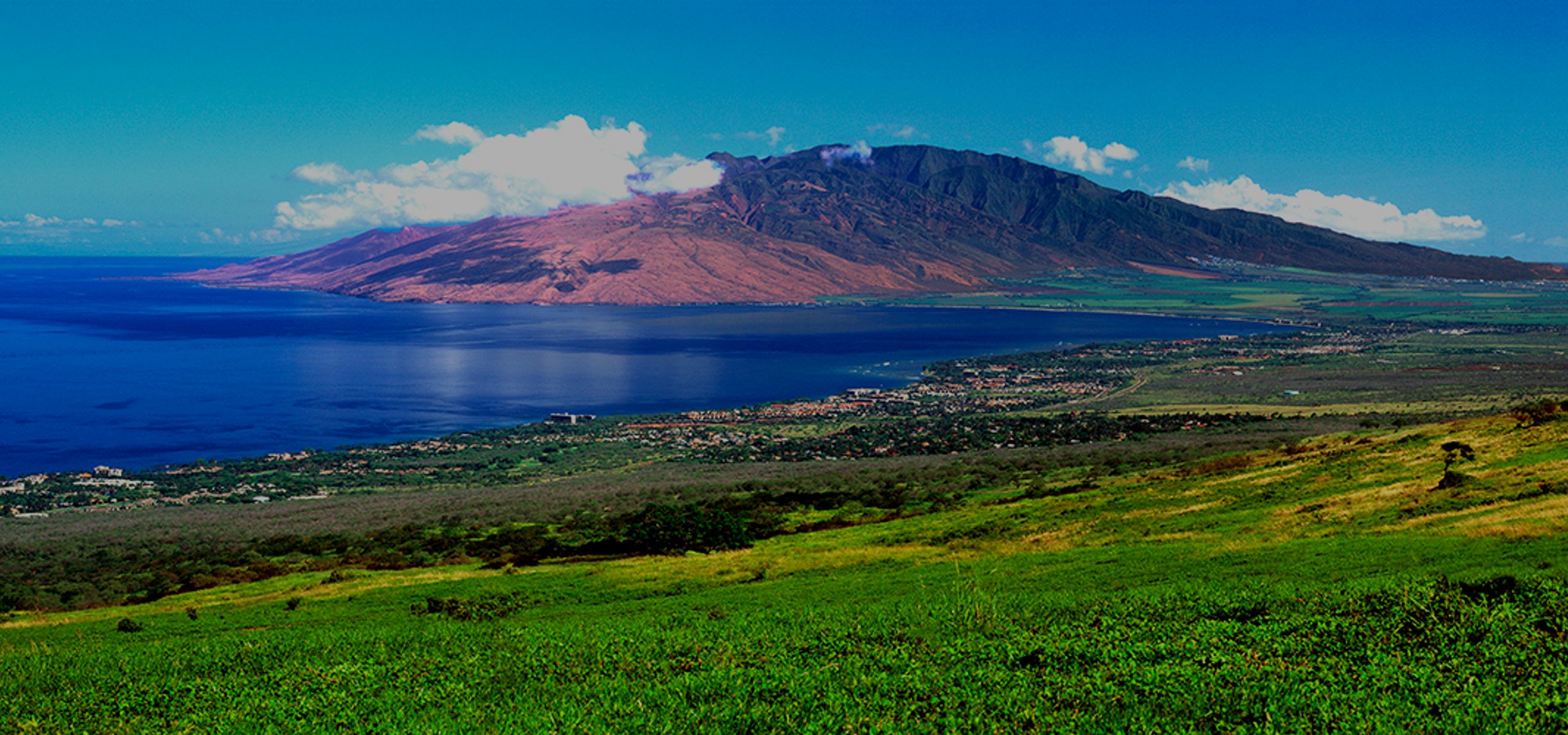
The project site is located on the western side of Maui, in Kihei. Access to the site is off Līpoa Parkway which is an improved paved road.

Natural Environment

  • Air quality -
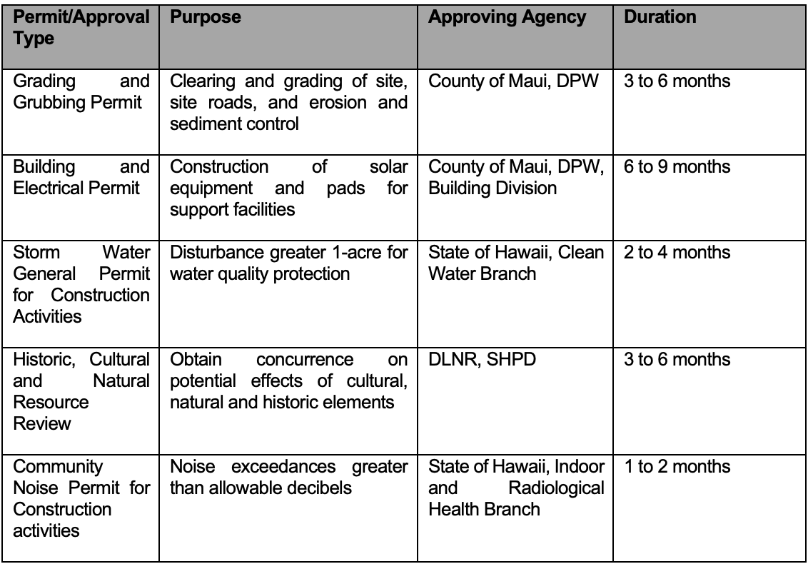
    • Temporary air quality may be impacted during construction through the generation of fugitive dust while grubbing and grading. The short time between original clearing, not disturbing more than necessary, and placement of ground cover will minimize and limit impacts. Mitigation measures during construction may include watering, application, soil cement products, and erection of dust fences.
    • Operation of the proposed facility does not result in emissions that have the ability to affect air quality and thus will have no negative effect on ambient air quality.
  • Biological Resources – no site flora or fauna surveys or reconnaissance was performed specifically to flora and fauna. The site has been vacant land for several decades and contains a mix of sparse grass and shrublands vegetation. A biological survey will be conducted during development to identify any potential flora or fauna resources requiring mitigation. No native Hawaiian plants are known at this time nor the presence of listed rare or endangered species. No significant adverse impacts are anticipated as a result of clearing or grubbing activities or site operations.
  • Climate – There are normally two seasons, summer and winter. Summer tends to be hot, muggy, windy, and partly cloudy, while winter is wetter and cooler. Winds vary throughout the year, and it is mostly clear year-round. Temperatures range between a low of 65 degrees F and 87 degrees F. The dry season lasts about 5 months from April to November while the wet season lasts almost 7 months from November to April. Monthly rainfall averages between 0.4 inches and 1.9 inches.
  • Soils – According to the U.S. Department of Agricultural Soil Conservation Service, Web Soil Survey, the soil type for the site consists of Waiakoa extremely stony silty clay loan with 3 to 25 percent slopes. The soil type appears well suited for facility construction and will not create a loss of land or risk of erosion.
  • Topography – the project is located on generally flat land to the slightly sloping ground with an average elevation between 250 to 300 feet mean sea level (MSL). The site topography does not pose any construction limitations or challenges.
  • Geology – According to the USGS, the East Maui volcano, known more widely as Haleakalā, is one of two volcanoes that make up the Island of Maui. West Maui is a deeply dissected volcano 5,788 feet high. The flat Isthmus connecting the two volcanoes was made by lavas from East Maui banking against the West Maui Mountains. The oldest rocks on West Maui are the very permeable primitive Wailuku basalts, which were extruded probably in Pliocene and early Pleistocene time from two rifts and from many radial fissures. The basalts form a dome about 5,600 feet high and extend an unknown distance below sea level. This sequence of flows, the Honomanu Basalt, is named after a site where the lava flows are well exposed. The risk from lava flows from Haleakalā is considered moderate. Haleakalā may erupt every 200 to 500 years, according to USGS, and this site is located in Zone 4 having the lowest flow risk.

    The island of Maui is currently classified as seismic zone 2B (Source: Uniform Building Code (D)). According to the record, eight magnitudes of 6.0 or larger events have occurred in Maui. The area most likely to experience effects would be the region with the most recent volcanic activity along the southeast and east rift zones of Haleakalā. The facility will be constructed in accordance with the D to withstand earthquake forces.

Land Regulations

  • Land Use – the project is located in the State land Use Agricultural District and Zoned Agricultural by the County of Maui. The project is generally bounded to the west by a golf course and some light industrial uses, to the south is farmland, and the remaining undeveloped. The proposed use is consistent with State and local land uses.
  • Flood and Tsunami – The project site is located outside the tsunami inundation zone. According to FEMA Flood Zone Maps, the solar facility is not located in a flood zone with minimal to no risk. 
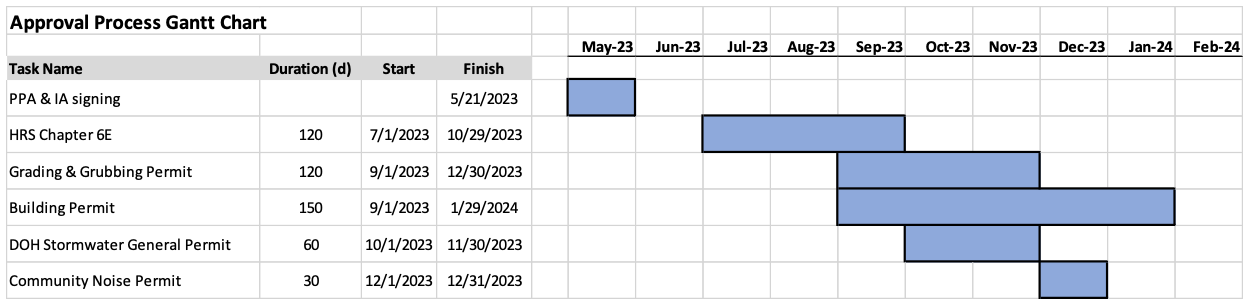
  • Noise – Solar Facilities are low noise generating sources and is unlikely that conditions would exceed the 50 dBA limits at the nearest external property line. Short-term noise during construction may be covered under a community noise permit if deemed necessary.
  • Roadway and Traffic – the primary access to the site will be off Līpoa Parkway, an improved paved road. Temporary construction traffic will have short-term effects due to the delivery of solar equipment and construction vehicles, but long-term impacts will be minimal with less than 4 vehicles per day accessing the site. This side road off the main highway is a low-volume traffic area.
  • Utilities – The proposed project does not require potable water service and would not affect existing water supplies for the adjacent properties. The facilities would plan to use Hawaiian Electric's telecommunication network to eliminate any potential burden to existing private or public telecommunications networks. Electrical export of electricity would be through underground or aboveground infrastructure interconnecting to existing power resources along an extension to Līpoa Parkway. No disruption or impact to utilities is expected as a result of the project.

Socio-Economic Characteristics

The project site is currently vacant, open space land, and with a Productivity Class rating of E, the lowest rating. The project will replace the vacant land use with beneficial productive economic use, e.g., lease from solar facility and production of clean renewable energy to the public utility. The project will not conflict with other adjacent land uses or economic activities. The project t is not intended to stimulate or otherwise promote population growth or other economic activity. Therefore, the project is not intended to have a significant effect on the socio-economic environment of the area.

Aesthetical and Visual Resources

The project is located in a relatively low-populated area along the lower slopes of west Haleakalā. It gently slopes upwards from the coastline and equipment and structure will not exceed 8 ft in height. There are no known public vantage points and would not be generally visible from the highway due to existing vegetation and trees. Therefore, the project would not have a significant impact on aesthetic or visual resources.

Solid Waste

Day-to-day operations will not generate or produce large volumes or unusual types of solid waste. During construction, solid waste will be generated from the packaging of delivered equipment and would be considered normal commodity waste (e.g., plastic, wood, cardboard). All waste generated will be properly disposed of or recycled at locally permitted facilities. No adverse or significant impacts are expected on the local collection or disposal facilities.

Hazardous Materials

The proposed project will not require large amounts of hazardous materials during construction or during operation. During construction, certain cleaners or corrosion protective material may be used but is maintained in small quantities at the site. During the operation of the facility, minimal amounts of cleaners for the solar panels may be present but would be non-toxic and biodegradable. No known releases of a hazardous substance are known to have occurred during ranching activities. No adverse or significant impacts are expected as a result of the minimal use of hazardous materials.

Water Quality

Besides the stream located on the northern boundary of the proposed project, there are no defined water bodies or wetlands. The site is located above a drinking water aquifer; however, the project will not inject any water into the ground. During construction, erosion and sediment control best management practices would be employed minimizing the potential for water quality impacts. Since the project does not generate any process waters or wastewater requiring disposal, the project does not have the potential to significantly affect water quality.

Public Safety Services

Solar facilities pose low-risk fire hazards due to the non-combustible materials used in the equipment. However, nearby uncontrolled ground fires could pose risk to the ground cover catching fire at the facility. The facility will be designed with site access roads meeting local fire code (e.g., 20-ft wide all-weather roads) to allow firefighting apparatus access to the site.

The project will be fully fenced with a locked gate. The facility will not pose a high risk to local police resources and the facility will be remotely monitored and private security forces will be available to investigate suspicious activity.

The proposed facility does not pose a significant health risk to workers. The closest medical facility is the Maui Memorial Medical Center. The project does not have a significant impact on public safety services.

Recreational Resources

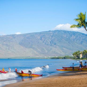
The closest recreational receptors are Kihei tourist (e.g., golf course) attractions and State beaches, but the facility will not pose any significant impacts as a result of operations.

Potential Cumulative and Secondary Impacts

The proposed project supports the State’s goal to produce 100% clean energy by 2045 and will help advance the achievement of that goal. The potential secondary impacts as a result of the development of the project are minimal and will not have significant impacts on the environment or public health and welfare.

proposal to ensure cultural sites are identified and carefully protected

Nexamp has been selected to work with PCSI, a local cultural and historic consultant familiar with the local approval process.

Existing Conditions

There is an abundance of dry-land agricultural features in the areas behind Kihei, Wailea, and Makena--likely more so to the south of Kihei. There are also historic ranch walls and other structures probably associated with Ulupalakua Ranch.

Potential Impacts and Analysis Methodology

The below discussion assumes that there is no Federal involvement that would trigger the Federal Section 106 process.

The typical historic preservation process includes requesting a Hawaii Revised Statute (HRS) 6E historic preservation review for each project area (either collectively or as separate projects) from the State Historic Preservation Division (SHPD) in order to obtain a “determination of effect” letter. The “Chapter 6E” package includes information that SHPD uses to evaluate the project. The package typically includes a letter providing an overview of the project as well as a historic preservation recommendation. SHPD will either concur with the recommendation or require additional information. In addition to the summary letter, the package will include a document justifying the recommendation (usually an Archaeological Literature Review [ALR], design or construction plans of the proposed project, as well as supporting photographs and other documents. For most projects, PCSI recommends a brief field inspection that is included in the ALR.

The recommended effects of a project will depend on the presence/absence of significant historic properties within and near the project area. The recommended effect can range from no effect with no additional historic preservation work required, to effect with additional historic preservation effort needed, such as archaeological monitoring during construction, an archaeological inventory survey prior to construction, a historic preservation plan, etc. The determination of effect will vary depending on the proposed project’s design, the location, and the presence or possible presence of significant historic properties, including human burials.

Initially, to determine if significant historic properties (not including architectural resources) are present or likely to be present within the project area, we will conduct background, archival, and land use research. Research would be conducted primarily at the following agencies and repositories:

  • State Historic Preservation Division (SHPD) through their HICRIS system or in person at the SHPD library in Kapolei;
  • The Hawaii Department of Accounting and General Services (DAGS) online archives and in-person (as necessary);
  • Library of Congress (online);
  • The Bernice P. Bishop Museum library and archives;
  • The University of Hawaii libraries and archives;
  • The Hawaii State Office of Planning and Sustainable Development Environmental Review Program (formally, the Office of Environmental Quality Control) archive; and
  • PCSI in-house cultural resources library

The background research would be included in the above-mentioned ALR along with other information for SHPD to consider such as project footprint and extent and depth of ground disturbance.

Understanding traditional and customary practices and rights is usually required as part of the HRS Chapter 343 (Environmental Assessments) rules and guidelines. When PCSI has been asked to be involved in EA and EIS work, we compile a Cultural Impact Assessment (CIA). The CIA typically includes the same information as an ALR, plus community consultation to determine if traditional and customary practices are or have been conducted within each project area. PCSI begins the process by contacting the SHPD to request a list of individuals with knowledge of the project areas. To cast a broader net, PCSI will also place a public notice in the Office of Hawaiian Affairs (OHA) Ka Wai Ola Newsletter. To determine if traditional and customary practices have or do occur in an area, PCSI hires an ethnographer to conduct interviews with individuals identified through the above process. If traditional and customary practices are identified, any resolution or mitigation would be dependent on the types of practices and the scope of the proposed project.

Mitigation Measures

Due to the abundance of historic properties, archeological construction monitoring may be necessary if no features or properties are not already identified. In addition, the following mitigation measures during construction are proposed:

  1. If cultural materials are discovered during construction, all earth-moving activity within and around the immediate discovery area will be diverted until a qualified archaeologist can assess the nature and significance of the find and SHPD will be notified as soon as possible.
  2. If human remains are discovered, Hawaii Administrative Rules Title 13, Subtitle 13, Chapter 300 states that further disturbances and activities shall cease in any area or nearby area suspected to overlie remains, and SHPD and Police Department will be contacted. If discovery occurs on Saturday, Sunday, or a holiday, the Division of Conservation and Resource Enforcement will be notified.

Proposers Experience

PCSI has extensive experience in compiling archaeological literature reviews and cultural impact assessments on Oʻahu, Maui, and Hawaiʻi Islands. On Oʻahu, PCSI or its personnel have conducted large-scale archaeological inventory surveys in Lualualei, Waianae, and Makua valleys as well as monitoring projects in Keaʻau, Waianae, and Makaha Ahupuaʻa. On Maui, PCSI has conducted archaeological inventory surveys in Makena and recently completed an archaeological inventory survey and monitoring for Hana Ranch. PCSI’s Principal Investigator has conducted an archaeological inventory survey and data recovery in Wailea. On Hawaiʻi Island, PCSI conducted extensive historic preservation planning, including archaeological excavations, mapping, and preservation documentation at the 1,500-acre Shoreline Park in coastal Kealakekua. PCSI personnel has conducted archaeological inventory surveys in the Waikaloa and Pohakaloa regions.

The proposed project involves construction and operation of a solar facility in Kihei, Hawaii. A conceptual layout plan is included (Drawing PV-101) showing the proposed solar and equipment arrangement, fencing, site roads, and connectivity to the power source. No known studies or assessments have been completed for the proposed project. A full file review of available studies or assessments from the landowner or agencies will be completed as part of the overall development and permitting plan.

Nexamp’s overall strategy for obtaining all required approvals and permits has or will include:

Siting the project in an area suitable for constructing the solar facility with regard to land use, zoning, and environmental setting with minimal impact on the environment.

Collecting and reviewing information from available reports, studies, and documents to acquire relevant information.

Minimizing land disturbance, utilizing existing ground topography, and locating equipment taking advantage of existing infrastructure.

Conducting early consultation with permitting authorities and other potential agencies to fully understand any concerns and develop any mitigation plans to address those concerns.

Performing site visits to confirm conditions are suitable and have not changed since initial siting and selection.

Taking into consideration surrounding property settings and impacts.

Completing necessary site investigations and studies or assessments to minimize the probability of encountering potential unknown adverse conditions during the design and construction process.

The agencies and authorities with the jurisdiction of the project include:

State of Hawaii, Department of Land and Natural Resources (DLNR), State Historic Preservation Division (SHPD)

Maui County Planning Department and Department of Public Works

State of Hawaii, Department of Health

No environmental studies for the project site have been conducted as part of current siting of the project. Available information from public resources, e.g., State and City and County GIS databases, Federal databased (e.g., USGS soil web survey) were reviewed to determine potential environmental or cultural/natural or historic impacts. No other studies or assessments were located or provided.

A Gantt format schedule which identifies the permitting and approval process is provided below:

Permits are generally independent of one another and can be prepared and submitted for review to agencies simultaneously. However, the grading permit, for example, cannot be approved without SHPD concurrence and are tied together.

Contact Us

Give us your questions, concerns, and business inquiries. We will get back to you as soon as we can.