
%20rotate(-315.000000)%20translate(-9.550253,%20-11.500000)%20'%20points='5.55025253%207.5%2013.5502525%207.5%2013.5502525%2015.5'%3e%3c/polyline%3e%3c/g%3e%3c/g%3e%3c/svg%3e)


Completing necessary site investigations and studies or assessments to thoroughly understand the land and topography and ensure a successful design and construction process. The agencies and authorities with the jurisdiction of the project include:
- The state of Hawaii, Department of Land and Natural Resources (DLNR), State Historic Preservation Division (SHPD)
- Hawaii County Planning Department and Department of Public Works
- State of Hawaii, Department of Health
No environmental studies for the project site have been conducted as part of the current siting of the project. Available information from public resources, e.g., State City and County GIS databases, and Federal databases (e.g., USGS soil web survey) were reviewed to determine potential environmental or cultural/natural or historic impacts. No other studies or assessments were located or provided.
The proposed 40-acre project is planned on a portion of 200 acres of land on a parcel located off Queen Kaahumanu Highway, Kailua-Kona, Hawaii. The parcel is zoned Residential (Hawaii County Real Property Tax Assessment Website) with a State Land Use District designation of Urban (U) (Hawaii GIS SLUD Locator). Since it is classified as Urban there is no Land Study Bureau (LSB) Productivity class rating. As provided in HRS 205-2(b), activities and land use in areas within the State urban district are regulated solely by County in which they occur. No special use permitting for zoning or land use is required. The project site and interconnection route are suitable within the current zoning and land use classifications.
The Hawaii County Code zoning regulations are found in Chapter 25. All general and specific use standards (e.g., setbacks and height) will meet minimum requirements.
A summary of anticipated permits and approvals required is provided below. A Gantt chart is also provided identifying the sequencing of applications and approvals. Certain permits may be submitted and processed at the same time. Durations are based on experience from other projects and best engineering judgment.
auto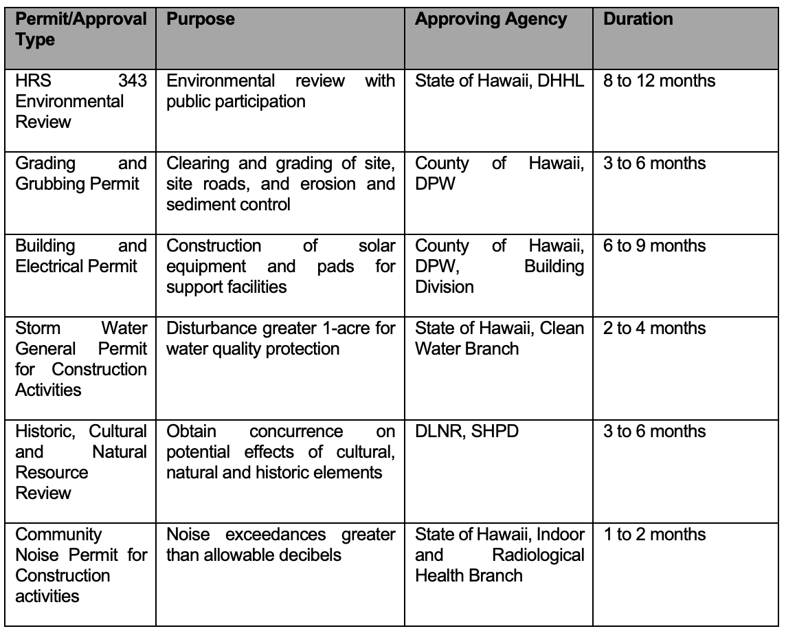
Hawaii Revised Statute (HRS) 343 applies to a project when, for example, there is the use of State land. This project is located in the Department of Hawaiian Home Land (DHHL), and as such, would require an environmental review process. The review process consists of preparing an Environmental Assessment to review potential concerns and to alert if any, any concerns to appropriate decision makers whether significant adverse effects may result from the implementation of certain actions.
Grading and grubbing permits are regulated under Hawaii County Code, Chapter 10. Grading or grubbing permits are required when excavating or filling earth materials, temporary storage of soil, sand, or rock, and/or uprooting or clearing vegetation in excess of certain thresholds.
Building permits are covered under Hawaii County Code Chapter 5 and are required for the construction, alteration, demolition, repair, and use of any building or structure within the county.
Stormwater general permits are regulated under Hawaii Administrative Rules (HAR 11-55) and are required when more than one of the land is disturbed. An applicant is required to submit the appropriate forms to the Department of Health, Clean Water Branch, for acceptance and approval. The applicant is also required to prepare a Storm Water Pollution Prevention Plan.
Since construction may involve noise exceedances during construction, the applicant will file for a Community Noise Permit, as applicable, with the DOH Indoor Radiological Health Branch.
Consultation with DLNR and SHPD will occur early in the development stages to determine whether any formal review is required and whether a Cultural Impact Assessment or Archeological Inventory Survey may be necessary, for example.
The proposed projects are intended to use renewable, non-polluting solar energy devices to sell power to the public utility. The following summary of potential effects is based on available information, including publicly available environmental databases. Where possible, identifiable existing conditions are provided and the short- and long-term direct, indirect, and cumulative impacts likely to result from the development, operation, and decommissioning of the projects.
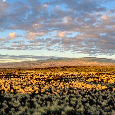
The project sites are located on the western side of Hawaii, in Kailua-Kona. Access to the site is off Queen Kaahumanu Highway, a State highway.
Natural Environment
Air quality -
Temporary air quality may be impacted during construction through the generation of fugitive dust while grubbing and grading. The short time between original clearing, not disturbing more than necessary, and placement of ground cover will minimize and limit impacts. Mitigation measures during construction may include watering, application, soil cement products, and erection of dust fences.
Operation of the proposed facility does not result in emissions that have the ability to affect air quality and thus will have no negative effect on ambient air quality.
Biological Resources – no site flora or fauna surveys or reconnaissance was performed specifically to flora and fauna. The site has been vacant land for several decades and contains a mix of sparse grass and shrublands vegetation. A biological survey will be conducted during development to identify any potential flora or fauna resources requiring mitigation. No native Hawaiian plants are known at this time nor the presence of listed rare or endangered species. No significant adverse impacts are anticipated as a result of clearing or grubbing activities or site operations.
Climate – the mean annual rainfall is between 8 and 30 inches. Temperature varies from 68 degrees F to 86 degrees F. The wind is diurnal with well-developed and reliable land and sea breezes, especially in the summer season. The area is sheltered from predominant regional Tradewinds by Mauna Loa and the light sea-breeze pattern prevails, with on-shore winds during the day and when the land heats up and offshore winds at night when the land cooled. Summer also tends to have a high frequency of late afternoon or early evening showers.
Soils – According to the U.S. Department of Agricultural Soil Conservation Service, Web Soil Survey, the soil type for the site consists generally of lava flows (e.g., pahoehoe) with 2 to 20 percent slopes. The ground appears well suited for facility construction and will not create a loss of land or risk of erosion.
Topography – The project is located on generally flat land to slightly sloping ground with an average elevation between 130 and 190 feet mean sea level (MSL). The site topography does not pose any construction limitations or challenges.
Geology – Hawaii island is still being formed by Mauna Loa and Kilauea volcanoes which lie over a hot spot on the Pacific plate. The site is located in the western rift zone of Mauna Kea (dormant) and Hualalai (active) volcanos. According to USGS, this site is located in Zone 3 having moderate risk, but less hazard since greater distances from recently active vents and because of topography.
The island of Hawaii is currently classified as seismic zone E, high hazard (Source: FEMA Earthquake Maps). The facility will be constructed in accordance with the UBC to withstand earthquake forces.
Land Regulations
Land Use – the project is located in the State land Use Urban District and Zoned Residential by the County of Hawaii. The project is generally bounded by developed and undeveloped lands and agricultural, residential, and industrial-zoned areas. The proposed use is consistent with State and local land uses.
Flood and Tsunami – The project site is located outside the tsunami inundation zone. According to FEMA Flood Zone Maps, the solar facility is not located in a flood zone with minimal to no risk.
Noise – Solar Facilities are low noise generating sources and is unlikely that conditions would exceed the 50 dBA limits at the nearest external property line. Short-term noise during construction may be covered under a community noise permit if deemed necessary.
Roadway and Traffic – the primary access to the site will be off Queen Kaahumanu Highway, a State Highway. Temporary construction traffic will have short-term effects due to the delivery of solar equipment and construction vehicles, but long-term impacts will be minimal with less than 4 vehicles per day accessing the site. This part of the highway is well-traveled and is the main gateway between the airport and Kona. Short delays exiting the site may occur occasionally during peak travel times.
Utilities – The proposed project does not require potable water service and would not affect existing water supplies for the adjacent properties. The facilities would plan to use the Hawaiian Electrics telecommunication network to eliminate any potential burden to existing private or public telecommunications networks. Electrical export of electricity would be through underground or aboveground infrastructure interconnecting to existing power resources along Keaau-Pahoa Road Road. No disruption or impact to utilities is expected as a result of the project.
Socio-Economic Characteristics
The project site is currently vacant, open space land in the urban district. The project will replace the vacant land use with beneficial productive economic use, e.g., lease from solar facility and production of clean renewable energy to the public utility. The project will not conflict with other adjacent land uses or economic activities. The project t is not intended to stimulate or otherwise promote population growth or other economic activity. Therefore, the project is not intended to have a significant effect on the socio-economic environment of the area.
Aesthetical and Visual Resources
The project is located on the lower slopes of Mauna Kea near and is gently sloping from the coastline to an upslope elevation. Equipment and structures will not exceed 8 ft in height. There are no known public vantage points and would not be generally visible from the highway due to existing vegetation and trees. Therefore, the project would not have a significant impact on aesthetic or visual resources.
Solid Waste
Day-to-day operations will not generate or produce large volumes or unusual types of solid waste. During construction, solid waste will be generated from the packaging of delivered equipment and would be considered normal commodity waste (e.g., plastic, wood, cardboard). All waste generated will be properly disposed of or recycled at locally permitted facilities. No adverse or significant impacts are expected on the local collection or disposal facilities.
Hazardous Materials
The proposed project will not require large amounts of hazardous materials during construction or during operation. During construction, certain cleaners or corrosion protective material may be used but is maintained in small quantities at the site. During the operation of the facility, minimal amounts of cleaners for the solar panels may be present but would be non-toxic and biodegradable. No known releases of hazardous substances are known to have occurred during ranching activities. No adverse or significant impacts are expected as a result of the minimal use of hazardous materials.
Water Quality
There are no defined water bodies or wetlands. The site is located below the Underground Injection Control Line in a non-drinking water source area; however, the project will not inject any water into the ground. During construction, erosion and sediment control best management practices would be employed minimizing the potential for water quality impacts. Since the project does not generate any process water or wastewater requiring disposal, the project does not have the potential to significantly affect water quality.
Public Safety Services
Solar facilities pose low-risk fire hazards due to the non-combustible materials used in the equipment. However, nearby uncontrolled ground fires could pose risk to the ground cover catching fire at the facility. The facility will be designed with site access roads meeting local fire code (e.g., 20-ft wide all-weather roads) to allow firefighting apparatus access to the site.
The project will be fully fenced with a locked gate. The facility will not pose a high risk to local police resources and the facility will be remotely monitored and private security forces will be available to investigate suspicious activity.
The proposed facility does not pose a significant health risk to workers. The closest medical facility is the Kona Community Hospital. The project does not have a significant impact on public safety services.
Recreational Resources
The closest recreational resource is the State coastline, but the facility will not pose any significant impacts as a result of operations.
Potential Cumulative and Secondary Impacts
The proposed project supports the State’s goal to produce 100% clean energy by 2045 and will help advance the achievement of that goal. The potential secondary impacts as a result of the development of the project are minimal and will not have significant impacts on the environment or public health and welfare.
proposal to ensure cultural sites are identified and carefully protected
Nexamp has been selected to work with PCSI, a local cultural and historic consultant familiar with the local approval process.
Existing Conditions
This general area has been studied in the past and it is likely to contain archeological sites, for example, lava tubes in this area have contained human burials in similar or like environments.
Potential Impacts and Analysis Methodology
The below discussion assumes that there is no Federal involvement that would trigger the Federal Section 106 process.
The typical historic preservation process includes requesting a Hawaii Revised Statute (HRS) 6E historic preservation review for each project area (either collectively or as separate projects) from the State Historic Preservation Division (SHPD) in order to obtain a “determination of effect” letter. The “Chapter 6E” package includes information that SHPD uses to evaluate the project. The package typically includes a letter providing an overview of the project as well as a historic preservation recommendation. SHPD will either concur with the recommendation or require additional information. In addition to the summary letter, the package will include a document justifying the recommendation (usually an Archaeological Literature Review [ALR], design or construction plans of the proposed project, as well as supporting photographs and other documents. For most projects, PCSI recommends a brief field inspection that is included in the ALR.
The recommended effects of a project will depend on the presence/absence of significant historic properties within and near the project area. The recommended effect can range from no effect with no additional historic preservation work required, to effect with additional historic preservation effort needed, such as archaeological monitoring during construction, an archaeological inventory survey prior to construction, a historic preservation plan, etc. The determination of effect will vary depending on the proposed project’s design, the location, and the presence or possible presence of significant historic properties, including human burials.
Initially, to determine if significant historic properties (not including architectural resources) are present or likely to be present within the project area, we will conduct background, archival, and land use research. Research would be conducted primarily at the following agencies and repositories:
- State Historic Preservation Division (SHPD) through their HICRIS system or in person at the SHPD library in Kapolei;
- The Hawaii Department of Accounting and General Services (DAGS) online archives and in-person (as necessary);
- Library of Congress (online);
- The Bernice P. Bishop Museum library and archives;
- The University of Hawaii libraries and archives;
- The Hawaii State Office of Planning and Sustainable Development Environmental Review Program (formally, the Office of Environmental Quality Control) archive; and
- PCSI in-house cultural resources library
The background research would be included in the above-mentioned ALR along with other information for SHPD to consider such as project footprint and extent and depth of ground disturbance.
Understanding traditional and customary practices and rights is usually required as part of the HRS Chapter 343 (Environmental Assessments) rules and guidelines. When PCSI has been asked to be involved in EA and EIS work, we compile a Cultural Impact Assessment (CIA). The CIA typically includes the same information as an ALR, plus community consultation to determine if traditional and customary practices are or have been conducted within each project area. PCSI begins the process by contacting the SHPD to request a list of individuals with knowledge of the project areas. To cast a broader net, PCSI will also place a public notice in the Office of Hawaiian Affairs (OHA) Ka Wai Ola Newsletter. To determine if traditional and customary practices have or do occur in an area, PCSI hires an ethnographer to conduct interviews with individuals identified through the above process. If traditional and customary practices are identified, any resolution or mitigation would be dependent on the types of practices and the scope of the proposed project.
Mitigation Measures
Archeological construction monitoring may not be necessary after conducting the required survey. In addition, the following mitigation measures during construction are proposed:
- If cultural materials are discovered during construction, all earth-moving activity within and around the immediate discovery area will be diverted until a qualified archaeologist can assess the nature and significance of the find and SHPD will be notified as soon as possible.
- If human remains are discovered, Hawaii Administrative Rules Title 13, Subtitle 13, Chapter 300 states that further disturbances and activities shall cease in any area or nearby area suspected to overlie remains, and SHPD and Police Department will be contacted. If discovery occurs on Saturday, Sunday, or a holiday, the Division of Conservation and Resource Enforcement will be notified.
Proposers Experience
PCSI has extensive experience in compiling archaeological literature reviews and cultural impact assessments on Oʻahu, Maui, and Hawaiʻi Islands. On Oʻahu, PCSI or its personnel have conducted large-scale archaeological inventory surveys in Lualualei, Waianae, and Makua valleys as well as monitoring projects in Keaʻau, Waianae, and Makaha Ahupuaʻa. On Maui, PCSI has conducted archaeological inventory surveys in Makena and recently completed an archaeological inventory survey and monitoring for Hana Ranch. PCSI’s Principal Investigator has conducted an archaeological inventory survey and data recovery in Wailea. On Hawaiʻi Island, PCSI conducted extensive historic preservation planning, including archaeological excavations, mapping, and preservation documentation at the 1,500-acre Shoreline Park in coastal Kealakekua. PCSI personnel has conducted archaeological inventory surveys in the Waikaloa and Pohakaloa regions.
The proposed projects involve the construction and operation of a solar facility in Kalaoa, Kailua-Kona, Hawaii. A conceptual layout plan is included (Drawing PV-101) showing the proposed solar and equipment arrangement, fencing, site roads, and connectivity to the power source. No known studies or assessments have been completed for the proposed project. A full file review of available studies or assessments from the landowner or agencies will be completed as part of the overall development and permitting plan.
Nexamp’s overall strategy for obtaining all required approvals and permits has or will include:
Siting the projects in an area suitable for constructing the solar facility with regard to land use, zoning, and environmental setting with minimal impact on the environment.
Collecting and reviewing information from available reports, studies and documents to acquire relevant information.
Minimizing land disturbance, utilizing existing ground topography, locating equipment taking advantage of existing infrastructure.
Conducting early consultation with permitting authorities and other potential agencies to fully understand any concerns and developing any mitigation plans to address those concerns.
Performing site visits to confirm conditions are suitable and have not changed since initial siting and selection.
Taking into consideration surrounding property settings and impacts.
Completing necessary site investigations and studies or assessments to minimize the probability of encountering potentially unknown adverse conditions during the design and construction process.
The agencies and authorities with the jurisdiction of the projects include:
The state of Hawaii, Department of Land and Natural Resources (DLNR), State Historic Preservation Division (SHPD)
Hawaii County Planning Department and Department of Public Works
State of Hawaii, Department of Health
No environmental studies for the project sites have been conducted as part of the current siting of the project. Available information from public resources, e.g., State City and County GIS databases, and Federal databases (e.g., USGS soil web survey) were reviewed to determine potential environmental or cultural/natural or historic impacts. No other studies or assessments were located or provided.
A Gantt format schedule that identifies the permitting and approval process is provided below:
auto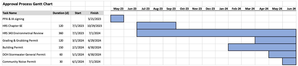
Permits are generally independent of one another and can be prepared and submitted for review to agencies simultaneously. However, the grading permit, for example, cannot be approved without SHPD concurrence and is tied together. Additionally, the projects are located on State lands and would require an environmental review under HRS 343. While receiving a result is not directly tied to receiving other permits, the projects may want to wait until the decision is finalized before proceeding with permits. The Chapter 6E review process would however need to be completed as part of the HRS 343 process.